The USA Disaster Situation Report
The Daily USA Disaster Situation Report
For April 21, 2001
Christopher Effgen, Editor, host{at}disastercenter.com
------------------------------------------------------------
IN THIS ISSUE
------------------------------------------------------------
=> USA Daily Temperature Extremes
=> Special Notes
=> Current Active National Weather Service Warnings:
=> Severe Weather Probability Forecast
=> Precipitation Forecast, Excessive Rainfall, Heavy Snow And/Or Significant
Icing Forecast
=> USA Flood Report
=> USA Fire Report and Forecast
=> USA Earthquake Report
=> Yesterday's USA Severe Weather Reports
=> Guest Column-
=> Sponsored by The Rothstein Catalog On Disaster Recovery
**** ARTICLES ****
=> Article How Did Eighty Nine Year Old House Survive Nisqually
Earthquake?
=> Article President Bush Statement on Recent Midwest Flooding
=> Article Volcano Watch - April 19, 2001 April is Earthquake and Tsunami
Awareness
Month
=> Classified Ads
=> Links Area
=> How to Be Featured as our Guest Columnist
------------------------------------------------------------
Sponsored by the The Rothstein Catalog On Disaster Recovery
http://www.disastercenter.com/Rothstein/
------------------------------------------------------------
=> Subscribe/Unsubscribe information
The Daily USA Disaster Situation Report
For April 21, 2001
Christopher Effgen, Editor, host{at}disastercenter.com
------------------------------------------------------------
IN THIS ISSUE
------------------------------------------------------------
=> USA Daily Temperature Extremes
=> Special Notes
*** RED FLAG WARNING IN FLORIDA FOR LOW RELATIVE HUMIDITY BELOW 35
PERCENT. ***
=> Current Active National Weather Service Warnings:
Active Warnings are no longer being provided to see current warning please
go to:
U.S. National Weather Service's Active Warning's page
http://iwin.nws.noaa.gov/iwin/graphicsversion/bigmain.html
=> Severe Weather Probability Forecast
The forecast probability of an event is by the stated percentage or greater
for the event, within 25 miles of any point for the area described.
Tornado Risk - Slightly Moderate
There is a 2% probability of a tornado over the Texas panhandle, northwest
Oklahoma, extreme
southeast Colorado, Kansas, except the far southeast area, south southeast
Nebraska, southern
Iowa, extreme central west Illinois, and the north northwest 1/3 of
Missouri. Also over north Illinois
except the western area, central east and southeast Wisconsin.
the 5% probability area covers the northeast portion of the Texas panhandle,
the eastern 1/2 of the
Oklahoma panhandle, Kansas except the south southeast and west northwest
areas.
Hail Risk - Moderately Severe
The 10% probability area for hail 2 inches or larger covers northeast
Kansas, extreme south
southeast Nebraska, extreme southeastern Iowa, and the north northwest 1/4
of Missouri.
There is a 5% probability of hail 3/4 inch or larger over central west
through northcentral Texas,
extreme east New Mexico, far east Colorado, the northwest 3/5 of Oklahoma,
the southern 1/2 of
Nebraska, Iowa except the north northwest area, Wisconsin except the far
northwest area,
Michigan, extreme northwest Ohio, the northwest 1/3 of Indiana, the north
northwest 3/4 of Illinois,
the north northwest 3/5 of Missouri, and Kansas.
The 15% probability area covers northwest Texas, the west northwest 1/3 of
Oklahoma, extreme
east southeast Colorado, south southeast Nebraska, the south southeast 1/2
of Iowa, the east
southeast 1/2 of Wisconsin, Michigan except the extreme northeast and
extreme northwest area,
extreme north northwest Indiana, the north northwest 1/2 of Illinois, the
north northwest 1/2 of
Missouri, and Kansas except the far south southeast area.
The 25% probability area covers the far north east portion of Texas's
panhandle, Kansas except the
south southeast and west northwest areas, extreme south southeast Nebraska,
extreme southeastern
Iowa, and the north northwest 1/4 of Missouri.
Wind Risk - Moderately Severe
There is a 5% probability of winds in excess of 50 knots over central west
through northcentral
Texas, extreme east New Mexico, far southeast and far central east Colorado,
the northwest 3/5 of
Oklahoma, south southeast Nebraska, south southeast and central east Iowa,
Wisconsin except the
west northwest area, Michigan, extreme northwest Ohio, northwest Indiana,
the north northwest 1/2
of Illinois, the north northwest 1/2 of Missouri, and Kansas.
The 15% probability area covers northwest Texas, the west northwest 1/3 of
Oklahoma, extreme
east southeast Colorado, extreme south southeast Nebraska, far south
southeast Iowa, the eastern
1/3 of Wisconsin, Michigan except the extreme northeast and extreme
northwest area, extreme north
northwest Indiana, the north northwest 1/2 of Illinois, the north northwest
1/2 of Missouri, and
Kansas except the far south southeast area.
The 25% probability area covers the far northeast portion of Texas's
panhandle, Kansas except the
south southeast and west northwest areas, and the north northwest 1/4 of
Missouri.
Tomorrow's Risk - Moderately Severe
http://www.spc.noaa.gov/products/outlook/expcomb.gif
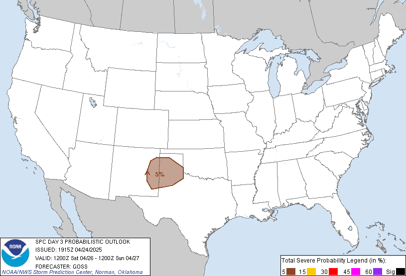
Day Three's Risk - Slight
http://www.spc.noaa.gov/products/outlook/day3prob.gif
=> Precipitation Forecast, Excessive Rainfall, Heavy Snow And/Or
Significant
Icing Forecast
Precipitation Forecast
The 24 hour precipitation forecast
http://www.hpc.ncep.noaa.gov/qpf/94q.gif
The 24 - 48 hour precipitation forecast
http://www.hpc.ncep.noaa.gov/qpf/98q.gif
Excessive Rainfall Forecast - Today
http://www.hpc.ncep.noaa.gov/qpf/94e.gif
USA heavy snow and/or significant icing
>From noon to midnight today EST
http://www.hpc.ncep.noaa.gov/qpf/93s.gif
>From midnight to noon tomorrow EST
http://www.hpc.ncep.noaa.gov/qpf/94s.gif
Current USA Snow and Ice Cover
http://www.rap.ucar.edu/weather/surface/us_NESDISsnow.gif
=> USA Flood Report
RIVER AND RESERVOIR SUMMARY
STAGE OBSERVATIONS ARE IN FEET. FOR OFFICIAL NWS RIVER FORECASTS...
CONSULT THE NWS RIVER FORECASTS PRODUCT...AS WELL AS NWS RIVER AND
FLOOD STATEMENTS...AND FLOOD WARNINGS.
LOCATION FS OBSV 24HR 24HR FLOW
6AM CHG PCPN CFS
MISSISSIPPI RIVER
LA CROSSE 12.0 15.90 -0.16 0.20
MCGREGOR 16.0 23.74 0.05 0.00
GUTTENBERG DAM 10 15.0 21.67 0.20 0.00 269000
DUBUQUE DAM 11 16.0 23.74 M 0.22 265208
DUBUQUE 17.0 25.97 1.19 0.18
BELLEVUE DAM 12 17.0 22.20 M 0.03 M
FULTON AT DAM 13 16.0 21.02 0.18 0.06 M
CAMANCHE 17.0 22.35 0.74 M
LE CLAIRE DAM 14 11.0 15.26 0.82 M 247282
QUAD CITIES DAM 15 15.0 20.40 0.80 0.01 M
ILLINOIS CITY AT DAM 16 15.0 20.06 M 0.00 M
MUSCATINE 16.0 21.25 0.56 0.00
NEW BOSTON AT DAM 17 14.0 19.90 M 0.07 M
KEITHSBURG 14.0 18.42 0.06 0.17
GLADSTONE AT DAM 18 10.0 15.34 0.68 0.33 277835
BURLINGTON 15.0 19.48 0.68 0.41
KEOKUK DAM 19 16.0 17.52 0.60 0.28 M
GREGORY LANDING 15.0 18.45 0.51 M
CANTON DAM 20 14.0 17.27 0.35 0.37 M
QUINCY 17.0 20.22 0.35 0.67
=> USA Fire Report and Forecast
INCIDENT MANAGEMENT SITUATION REPORT
FRIDAY, APRIL 20, 2001 - 1000 MDT
NATIONAL PREPAREDNESS LEVEL 1
CURRENT SITUATION:
A total of 15 new large fires were reported this past week in the Southern
Area and two in the Eastern Area. Initial attack activity is moderate in
the Southern Area and light elsewhere in the nation. Large fire activity
has increased in the Southern Area due to continued drought conditions.
SOUTHERN AREA LARGE FIRES:
CAR 01, Florida Division of Forestry. The fire is burning near Northport,
FL. The fire jumped I-75, one home and one outbuilding lost.
PARK, Florida Division of Forestry. The fire is burning in Okachobee
County, FL. Windy conditions and low relative humidity are contributing to
containment problems.
CATHERINE ISLAND, Florida Division of Forestry. This fire is burning in
Collier County, FL. No other information reported.
SCOUT CAMP, Florida Division of Forestry. This fire is burning in Osceola
County, FL. The fire escaped containment and threatened homes. Crews are
currently working hot spots with the assistance of a helicopter.
HORIZON, Florida Division of Forestry. This fire is in Highlands County,
FL. Crews are monitoring and working containment firelines. Additional
resources have been ordered.
BLACK SINK PRAIRIE, Florida Division of Forestry. This fire is near Citra,
FL. Crews continue to mop up.
RAT, Florida Division of Forestry. This fire is in Dixie County, FL.
Structure protection is being provided.
PATTERSON, Florida Division of Forestry. No other information has been
provided.
PINEWOOD, Shaw Air Force Base. The fire is burning near Sumter, SC.
Burnout operations have been performed. Low relative humidity continue to
be a concern.
WALTER HUNTER, Florida Division of Forestry. No other information was
reported.
SNOW DROP, Florida Division of Forestry. This fire is located in Sarasota
County, FL.
BIG BUCK, Florida Division of Forestry. The fire is burning in Bradford
County, FL. This will be the last report unless new information is
received.
OUTLOOK:
*** RED FLAG WARNING IN FLORIDA FOR LOW RELATIVE HUMIDITY BELOW 35
PERCENT. ***
High pressure will keep the temperatures in the South at or above normal.
A slight chance of showers is forecasted for central and southern Florida
as a weak trough of low pressure moves in from the Bahamas. Daytime high
temperatures will range from the low 80's over much of the Gulf Coast to
the mid 70's in the Carolinas.
An upper level low pressure system is moving into the Pacific Northwest
bringing rain showers and thunderstorms across much of northern
California, Oregon and southwest Washington. A cold front dropping down
out of Canada will bring rain showers and windy conditions to the Rockies.
The Southwest and southern California will remain under clear skies with
high temperatures in the low 80's. Daytime high temperatures for the rest
of the region will be in the 40's to 60's.
Rain is expected over the Ohio Valley as a cold front passes through the
area. Hail, wind, and isolated tornados are likely to occur. A weak
disturbance will also bring showers across Detroit, Cleveland, and
Pittsburgh today. High temperatures will range from the 40's and 50's
across the northern Plains to the 80's across the central Plains.
A few showers are forecasted across parts of New York state and
Pennsylvania as a warm front cross the area. High pressure will keep the
rest of the Northeast under partly sunny skies with mild temperatures.
High temperatures will range from the 40's and 50's across northern New
England to the 60's elsewhere.
=> USA Earthquake Report
UNITED STATES GEOLOGICAL SURVEY
NATIONAL EARTHQUAKE INFORMATION CENTER
GOLDEN, COLORADO
LISTS OF U.S. EARTHQUAKES IN THE LAST 30 HOURS
Prepared by USGS/NEIC 2001 APR 21 at 00:15 UTC
EARTHQUAKES IN SOUTHWESTERN UNITED STATES
(29.0 TO 35.8 N, 102.0 TO 125.0 W)
Date Time (UTC) Lat Long Depth Magnitude
2001 APR 20 09:52:12.00 33.7 N 116.8 W 7 km 3.0
10 miles ESE of Hemet, California
EARTHQUAKES IN WEST CENTRAL UNITED STATES
(35.8 TO 40.3 N, 102.0 TO 125.0 W)
Date Time (UTC) Lat Long Depth Magnitude
2001 APR 20 07:30:44.00 36.9 N 121.6 W 7 km 2.5
10 miles S of Gilroy, California
2001 APR 20 13:52:55.00 37.5 N 118.7 W 8 km 2.9
20 miles WNW of Bishop, California
EARTHQUAKES IN NORTHWESTERN UNITED STATES
(40.3 TO 50.0 N, 102.0 TO 125.0 W)
EARTHQUAKES IN STATE OF ALASKA
Date Time (UTC) Lat Long Depth Magnitude
2001 APR 20 10:29:13.52 56.3 N 157.9 W 63 km 4.9
20 miles E of Chignik, Alaska
=> Yesterday's USA Severe Weather Reports
Note: All data is considered preliminary
Tornado Reports
Time F-Scale Location County State Lat Lon Comments
1845 UNK SWEETWATER COUNTY SWEETWATER WY 4161 10880 *** 0 INJ ***
COUPLE OF SHEDS DESTROYED BY 2 TORNADOES (RIW)
0030 UNK 3 NE EMERSON DAKOTA NE 4238 9656 REPORTED BY STORM SPOTTER.
BRIEF TOUCHDOWN. (FSD)
0050 UNK 5 S ROSELAND ADAMS NE 4038 9855 BRIEF TORNADO REPORTED BY
ROSELAND FIRE DEPARTMENT. (GRI)
0116 UNK 17 SW HARTINGTON CEDAR NE 4241 9753 REPORTED BY LAW
ENFORCEMENT OFFICIAL. (OMA)
0120 UNK 1 W SUPERIOR NUCKOLLS NE 4003 9808 SPOTTER REPORTED BRIEF
TOUCHDOWN. A FEW POWER LINES DOWN. ROOF OF APARTMENT BUILDING
BLOWN INTO ANOTHER NEARBY BUILDING. WINDOWS WERE ALSO BLOWN OUT.
(GRI)
0543 UNK 3 W IOWA FALLS HARDIN IA 4251 9333 REPORTED BY PUBLIC.3
BUSINESSES DESTROYED (DSM)
Hail Reports
Time Size Location County State Lat Lon Comments
2150 75 BENKELMAN DUNDY NE 4004 10153 (GLD)
2217 100 PALISADE HITCHCOCK NE 4034 10109 (GLD)
2314 75 VALLEY FALLS JEFFERSON KS 3933 9546 (TOP)
2345 75 PALCO ROOKS KS 3925 9956 (GRI)
2355 75 3 NW CUMMINGS ATCHISON KS 3950 9529 REPORTED BY LAW
ENFORCEMENT OFFICIAL. (MCI)
2355 88 TROY DONIPHAN KS 3978 9508 REPORTED BY LAW ENFORCEMENT
OFFICIAL. (MCI)
2355 75 1 SW CALLAWAY CUSTER NE 4128 9994 (LBF)
0000 100 LAMAR CHASE NE 4056 10196 (LBF)
0005 75 3 SE NEW PT HOLT MO 4001 9503 REPORTED BY PUBLIC. (MCI)
0006 75 YOCEMENTO ELLIS KS 3890 9941 (DDC)
0018 100 3 SW FILLMORE ANDREW MO 3999 9502 REPORTED BY PUBLIC. 60 MPH
WIND GUST (MCI)
0020 75 FRANKLIN FRANKLIN NE 4009 9894 (GRI)
0030 150 2 SW RUSSELL RUSSELL KS 3885 9888 REPORTED BY AGTAP (ICT)
0030 75 SMITH COUNTY SMITH KS 3976 9883 HAIL REPORTED IN NORTHERN
PART OF COUNTY. (GRI)
0042 75 OTIS RUSH KS 3853 9904 (DDC)
0044 100 BARTON COUNTY BARTON KS 3846 9874 REPORTED BY PUBLIC (ICT)
0045 275 6 W PARNELL NODAWAY MO 4043 9476 REPORTED BY LAW
ENFORCEMENT OFFICIAL. (MCI)
0047 100 3 N ALBERT ELLSWORTH KS 3850 9901 REPORTED BY AGTAP SPOTTER.
(ICT)
0051 175 SUSANK BARTON KS 3863 9876 REPORTED BY PUBLIC. (ICT)
0051 88 6 N PONCA DIXON NE 4266 9669 REPORTED BY STORM SPOTTER. (FSD)
0054 100 AKRON PLYMOUTH IA 4283 9655 REPORTED BY LAW ENFORCEMENT
OFFICIAL. (FSD)
0108 100 2 N WILSON ELLSWORTH KS 3884 9846 REPORTED BY PUBLIC. (ICT)
0110 100 RUSSELL COUNTY RUSSELL KS 3890 9876 REPORTED BY PUBLIC. (ICT)
0110 175 3 SW SYLVAN GROVE LINCOLN KS 3898 9842 REPORTED BY AGTAP
SPOTTER. (ICT)
0110 75 1 W GROVE LINCOLN KS 3918 9588 REPORTED BY 911. (ICT)
0110 75 2 N WILLIS DAKOTA NE 4251 9661 REPORTED BY STORM SPOTTER. (FSD)
0120 75 3 ESE GRANT PERKINS NE 4083 10165 (LBF)
0128 75 JAMESTOWN CLOUD KS 3959 9786 60 MPH WND (TOP)
0128 100 3 SW COLERIDGE CEDAR NE 4246 9724 REPORTED BY STORM SPOTTER.
(OMA)
0130 100 ST JAMES CEDAR NE 473 9713 REPORTED BY COOPERATIVE OBSERVER.
(OMA)
0135 75 7 W OBERLIN DECATUR KS 3981 10066 REPORTED BY STORM SPOTTER.
(GLD)
0135 75 5 NE REPUBLIC REPUBLIC KS 3997 9773 (TOP)
0137 100 5 NW CLAFLIN BARTON KS 3857 9860 REPORTED BY PUBLIC. (ICT)
0137 150 VERMILLION CLAY SD 4278 9691 REPORTED BY FIRE DEPARTMENT
OFFICIAL. (FSD)
0139 175 8 S LINCOLN LINCOLN KS 3889 9814 REPORTED BY 911. (ICT)
0145 75 HEBRON THAYER NE 4016 9758 (GRI)
0152 100 GLENDALE SALINE KS 3890 9786 REPORTED BY AGTAP SPOTTER. (ICT)
0205 175 EVERLY CLAY IA 4316 9533 REPORTED BY PUBLIC. (FSD)
0213 100 KANOPOLIS ELLSWORTH KS 3871 9814 REPORTED BY AGTAP SPOTTER
(ICT)
0214 88 5 W SALINA SALINE KS 3883 9770 REPORTED BY NWS EMPLOYEE. (ICT)
0215 150 2 WSW ORANGE CITY SIOUX IA 4300 9609 REPORTED BY STORM
SPOTTER. (FSD)
0225 75 6 W MILFORD DICKINSON IA 4333 9528 REPORTED BY STORM SPOTTER.
(FSD)
0230 175 SALINA SALINE KS 3883 9759 SOUTH SIDE OF SALINA. REPOR 911. 1.75
INCH HAIL REPORTED BY AGTAP SPOTTER. (ICT)
0230 75 2 E NILES OTTAWA KS 3896 9742 (TOP)
0230 75 JOHNSON GOSPER NE 4041 9600 (GRI)
0230 88 LINCOLN LANCASTER NE 4079 9666 REPORTED BY EMERGENCY
MANAGEMENT. (OMA)
0230 75 DAWSON COUNTY DAWSON NE 4086 9981 REPORTED BY DAWSON CO
SHERIFFS OFFICE. (GRI)
0230 75 5 N ORANGE CITY SIOUX IA 4309 9604 REPORTED BY PUBLIC. (FSD)
0250 100 SALINA SALINE KS 3883 9759 REPORTED BY AGTAP SPOTTER. (ICT)
0253 75 3 NNE AKRON PLYMOUTH IA 4287 9652 REPORTED BY PUBLIC. (FSD)
0302 88 2 N NEWKIRK SIOUX IA 4309 9594 REPORTED BY STORM SPOTTER. (FSD)
0307 88 8 SW ABILENE DICKINSON KS 3882 9733 (TOP)
0309 88 2 W (OFF)OFFUTT AFB SARPY NE 4111 9596 REPORTED BY STORM
SPOTTER. (OMA)
0314 100 ROLFE POCAHONTAS IA 4281 9451 REPORTED BY LAW ENFORCEMENT
OFFICIAL. (DSM)
0315 75 5 S HAWARDEN SIOUX IA 4291 9646 REPORTED BY LAW ENFORCEMENT
OFFICIAL. (FSD)
0322 88 MAY CITY OSCEOLA IA 4331 9548 (FSD)
0325 88 7 S ABILENE DICKINSON KS 3879 9721 (TOP)
0332 88 1 W HUMBOLDT HUMBOLDT IA 4271 9423 REPORTED BY LAW
ENFORCEMENT OFFICIAL. (DSM)
0333 100 5 E ENTERPRISE DICKINSON KS 3889 9700 FUNNEL CLOUD (TOP)
0335 75 PIERSON WOODBURY IA 4254 9588 REPORTED BY FIRE AND RESCUE.
(FSD)
0335 88 12 W HUMBOLDT HUMBOLDT IA 4271 9448 REPORTED BY STORM
SPOTTER. (DSM)
0343 125 PLOVER POCAHONTAS IA 4288 9463 REPORTED BY LAW ENFORCEMENT
OFFICIAL. (DSM)
0343 88 SANBORN OBRIEN IA 4310 9558 REPORTED BY STORM SPOTTER. (FSD)
0344 75 9 W SPIRIT LAKE DICKINSON IA 4343 9530 REPORTED BY PUBLIC. (FSD)
0350 75 SIOUX CITY WOODBURY IA 4249 9638 REPORTED BY STORM SPOTTER.
(FSD)
0350 100 ROYAL CLAY IA 4306 9528 REPORTED BY PUBLIC. (FSD)
0401 100 3 W EMMETSBURG IA 4311 9476 EVENT DURATION 5 MINUTES.
REPORTED BY LAW ENFORCEMENT OFFICIAL. (DSM)
0412 100 13 SW HOLTON JACKSON KS 3931 9594 (TOP)
0412 100 WALLINGFORD EMMET IA 4333 9483 REPORTED BY LAW ENFORCEMENT
OFFICIAL. (DSM)
0433 100 MAPLE HILL WABAUNSEE KS 3908 9603 (TOP)
0436 88 BURT KOSSUTH IA 4319 9421 REPORTED BY LAW ENFORCEMENT
OFFICIAL. (DSM)
0437 175 HOYT JACKSON KS 3925 9569 (TOP)
0438 100 ELLSWORTH COUNTY ELLSWORTH KS 3869 9820 REPORTED BY AGTAP
SPOTTER (ICT)
0438 100 17 NE ELLSWORTH ELLSWORTH KS 3893 9797 REPORTED BY AGTAP
SPOTTER (ICT)
0439 175 2 W RINGSTED EMMET IA 4329 9456 REPORTED BY MEDIA. KICD RADIO.
(DSM)
0440 100 WILLARD SHAWNEE KS 3909 9594 (TOP)
0447 75 MARYDEL SALINE KS 3894 9769 REPORTED BY AGTAP SPOTTER (ICT)
0451 175 OZAWKIE JEFFERSON KS 3921 9544 (TOP)
0455 100 CRYSTAL LAKE HANCOCK IA 4321 9380 REPORTED BY LAW
ENFORCEMENT OFFICIAL. (DSM)
0459 175 4 N TOPEKA SHAWNEE KS 3911 9568 (TOP)
0500 100 WINCHESTER JEFFERSON KS 3931 9526 (TOP)
0505 175 FRASER BOONE IA 4213 9396 REPORTED BY LAW ENFORCEMENT
OFFICIAL. (DSM)
0514 88 JEWELL HAMILTON IA 4229 9364 REPORTED BY HAM RADIO OPERATOR.
(DSM)
0515 175 OZAWKIE JEFFERSON KS 3921 9544 QUARTER SIZE UP (TOP)
0515 100 1 E ALTA VISTA DAVIESS MO 3989 9417 DIME TO QUARTER SIZE HAIL
REPORTED AT INTERSECTION OF 6 HIGHWAY AND INTERSTATE 35. EVENT
DURATION 3 MINUTES. (MCI)
0515 100 2 NW FOREST CITY WINNEBAGO IA 4329 9368 REPORTED BY
MEDIA.KIOW RADIO (DSM)
0520 88 SOLOMON DICKINSON KS 3891 9736 (TOP)
0525 100 ELLSWORTH ELLSWORTH KS 3873 9823 REPORTED BY AGTAP. (ICT)
0525 75 WEATHERBY DE KALB MO 3991 9425 DIME SIZE HAIL REPORTED ABOUT
10 MILES NORTH OF CAMERON. (MCI)
0535 75 2 N GOFF NEMAHA KS 3969 9591 (TOP)
0545 75 HURON ATCHISON KS 3963 9534 REPORTED BY LAW ENFORCEMENT
OFFICIAL. (MCI)
0545 175 6 W MERCIER BROWN KS 3969 9572 (TOP)
0550 100 BROOKVILLE SALINE KS 3876 9786 REPORTED BY AGTAP (ICT)
0608 75 SALINA SALINE KS 3883 9759 REPORTED BY TRAINED SPOTTER AIRPORT.
(ICT)
0645 75 1 NW ROSSVILLE SHAWNEE KS 3914 9596 (TOP)
Wind Reports
Time Speed Location County State Lat Lon Comments
2000 UNK 30 S YUMA YUMA CO 3961 10271 HALF A QUANSET SMASHED.
REPORTED BY STORM SPOTTER. (GLD)
2230 UNK VERNON YUMA CO 3993 10228 SPRINKLER TURNED ON SIDE AND
GRAIN BINS IN A DITCH. REPORTED BY PUBLIC. (GLD)
2328 UNK ALAMOTA LANE KS 3845 10031 ELECTRIC POLES DOWN, NO
ELECTRICITY IN ALAMOTA (DDC)
2328 UNK SHIELDS LANE KS 3861 10044 ELECTRIC POLES DOWN, NO
ELECTRICITY IN SHIELDS (DDC)
2349 UNK 2 W ELLIS ELLIS KS 3893 9959 2 SEMI-TRAILERS TOPPLED OVER ON
I-70 (DDC)
0005 UNK PLAINVILLE ROOKS KS 3923 9930 (GRI)
0005 UNK 10 S WRAY YUMA CO 3991 10223 BUNCH OF GRAIN BINS DESTROYED.
25-30 POWER POLES DOWN. REPORTED BY STORM SPOTTER. (GLD)
0010 UNK 3 SE PHILLIPSBURG PHILLIPS KS 3971 9927 BARN DESTROYED. ROOFS
TORN OFF OUTBUILDINGS. POWER LINES DOWN. DECK TAKEN FROM FARM
HOUSE. (GRI)
0030 UNK 14 N PARKS DUNDY NE 4028 10171 POWER LINES DOWN. REPORTED
BY STORM SPOTTER. (GLD)
0045 UNK LAMAR CHASE NE 4056 10196 60 MPH WIND GUST (LBF)
0050 UNK IMPERIAL CHASE NE 4051 10163 60 MPH WIND GUST (LBF)
0056 UNK 10 S SCOTT CITY SCOTT KS 3831 10090 POWER LINES DOWNED, CARS
BLOWN INTO DITCH (DDC)
0125 UNK 3 NE SUPERIOR NUCKOLLS NE 4006 9802 MACHINE SHED BLOWN
OVER. OUT BUILDING ALSO DAMAGED. REPORT RELAYED BY RADIO STATION
KRFS. TIME APPROXIMATE. (GRI)
0147 UNK 8 E DICKENS LINCOLN NE 4081 10080 70 MPH WIND GUST (LBF)
0215 UNK FRIEND SALINE NE 4064 9728 ROOF BLOWN OFF HORSE BARN AND
MACHINE (OMA)
0311 UNK 3 W SPRINGFIELD SARPY NE 4108 9619 WINDS GREATER THAN 50 MPH.
TREES AND (OMA)
0325 UNK FRIEND SALINE NE 4064 9728 TREES AND BARN DOWNN NEAR
FRIEND. REPORTED BY LAW ENFORCEMENT OFFICIAL. (OMA)
0335 UNK PAPILLION SARPY NE 4116 9604 SOME ROOFS BLOWN OFF IN
PAPILLION. REPORTED BY LAW ENFORCEMENT OFFICIAL. (OMA)
0430 UNK JEFFERSON GREENE IA 4201 9438 LARGE TREES DOWN . REPORTED BY
LAW ENFORCEMENT OFFICIAL. (DSM)
0501 UNK STRATFORD HAMILTON IA 4226 9393 REPORTED BY LAW
ENFORCEMENT OFFICIAL.LARGE TREES DOWN AND BUILDING DESTROYED
(DSM)
0530 UNK 4 S STANHOPE HAMILTON IA 4221 9380 REPORTED BY KCCI
TVMEDIA.FARM BUILDING ROOF BLOWN OFF (DSM)
Fields marked UNK are unknown
All Times UTC
Wind Gusts in MPH
Hail Sizes in 1/100 of an Inch (75 = 0.75")
=> Guest Column
------------------------------------------------------------
SPONSORSHIP NOTICE
THE ROTHSTEIN CATALOG ON DISASTER RECOVERY
The Rothstein Catalog On Disaster Recovery is the largest on line source of
Business Continuity, Disaster Recovery, IT Disaster Recovery, Software,
CD/Diskette Products,
Videos, Management Issues, Exercising Contingency Plans, Telecommunications,
Networks, Call
Centers, Help Desks, Crisis Management, Crisis Communications, Risk
Management, Business
Impact, Disaster Prevention, Avoidance Info, Network Security, Info
Protection, Service Levels,
Service Quality, Natural Hazards -- Earthquakes, Hurricanes.... Business
Records, Libraries,
Media, Banking, Finance, Govt Regs/Guidelines, Emergency Management,
Industrial, Terrorism,
Workplace Violence, Crime, Physical, Financial Security, and other Valuable
Resources, Tools.
http://www.disastercenter.com/Rothstein/.
--------------------------------------------------------------
**** ARTICLES ****
--------------------------------------------------------------
=> How Did Eighty Nine Year Old House Survive Nisqually Earthquake?
Olympia, WA, April 19, 2001 -- The neat little white house still sits on a
Poulsbo hill and does not
look its 89 years. It looks the same as it did before the February 28
earthquake that shook the Puget
Sound area with violence measured at 6.8.
But there is a hidden difference. Before the quake, the house was just
there, sitting. Now it hunkers
down, ready to stubbornly resist the next shaking by tectonic plates.
The difference cost barely $3,300 and is pretty much low tech: some hunks of
plywood, a collection
of two-by-six inch planks and two-foot metal straps, nails, anchor pins and
about 40-hours of work
by a contractor.
That is Mrs. Doris Chapot's dream home and it details in layman's terms the
vaguely understood
words "mitigation" and "retrofitting." Without that work, the home could
well have been tipped from
its underpinnings or maybe been sent on a downhill slide toward Liberty Bay,
with the 80-year-old
occupant along for a frightening ride.
Instead, "Not one thing in the house fell or broke. The house rode
beautifully," she told a mitigation
worker for the Federal Emergency Management Agency (FEMA).
When Mrs. Chabot, widow of a building contractor, moved from California in
1998, her home was
perched on 40 six-by-six inch posts. Those posts, each about 24-inches tall,
stood atop 10 or
12-inch high pier blocks and were spaced out every six feet around the
circumference of the home.
One row of them ran down the middle of home--only gravity kept things in
place.
>From her life in California, Mrs. Chabot knew about earthquakes and the
importance of mitigation.
After recovering from a health problem, she contacted Northwest Renovations
and met contractor
Rich Reidesel.
Reidesel learned that the comfortable home was built in 1902 as a church
parsonage and was moved
to its present location in 1940, when it was placed on the posts and pier
blocks.
Working in the two feet of crawl space under the house, Reidesel linked the
posts with stout planks
and nailed metal straps to the posts. The bottom of each strap was anchored
to a pier block with a
stout sheer pin.
Slabs of thick plywood were nailed in place as gussets linking the beams
under the home's floor to
the posts and the planks. Reidesel's work is an example of only one of a
variety of mitigation
methods.
"I do know the importance of this work and I remember having my homes in
California retrofitted
because of earthquakes," Mrs. Chabot said. Those homes survived several good
shakings.
"When this quake hit, I was in a little sitting room on the second floor,
looking through some books.
It felt like almost a circular rolling motion instead of a jolting," she
said.
"The only things that moved in the house were a couple of pictures that
tipped a little and some
books on a table downstairs. There were too many books for the little book
ends to hold," Mrs.
Chabot said.
Prior to the Nisqually quake, Mrs. Chabot quickly learned that Reidesel's
work had made her home
safer.
"Before I could feel the house vibrate when heavy trucks drove by. I have my
washer and dryer in a
little service alcove at the back of the house. When they were running, my
lamps would rattle.
"Now," Mrs. Chabot said proudly, "I don't feel anything. I don't feel the
trucks, nothing moves when
my washer and dryer are working." The house survived the quake with
absolutely no damage, and
Mrs. Chabot only had to straighten a couple of pictures and pick up a few
spilled books.
Reidesel was equally happy with his work. "It withstood the quake the way we
believed it would."
The timing of events on Feb. 28 tickled him. He telephoned Mrs. Chabot that
morning, alerting her
that he would stop to pick up her check for the final payment for the work.
The Nisqually quake got to her house before he did.
=> President Bush Statement on Recent Midwest Flooding
Office of the Press Secretary, Washington, DC, April 19, 2001 -- "I know
that all Americans share
my concern for the displaced families and residents of Wisconsin, Iowa,
Minnesota, and Illinois.
Yesterday, the Mississippi River engulfed homes and businesses. Even more
flooding is predicted in
the upcoming days.
Those who live and work along the upper Mississippi are not strangers to the
threat of Spring floods.
Since the 1993 floods, many communities and residents have taken measures to
protect themselves
and their property. They are to be commended for this preventative work.
At my direction, FEMA Director Joe Allbaugh and his staff are working
closely with State and local
officials throughout the impacted and threatened areas to closely track the
flooding and any further
damage. As I travel to Canada for the Summit of the Americas, I will
continue to monitor the
situation."
- President George W. Bush
=> Volcano Watch - April 19, 2001 April is Earthquake and Tsunami
Awareness Month
Early Monday morning, residents of the northern half of the island
were awakened by a magnitude-3.9 earthquake. This was a gentle reminder
that we live in one of most seismically active areas in the United States.
The month of April is observed as earthquake awareness month in the State
of California and as tsunami awareness month in the State of Hawaii. Both
natural hazards have struck this island with disastrous results, so it is
especially important that kama`ainas are reminded, and malihinis are made
aware, of these hazards.
April could also be considered earthquake awareness month here in
Hawai`i because the largest historical earthquake occurred on April 3,
1868, in the Ka`u district. The estimated magnitude of this event was 7.9,
larger than the magnitude-7.8 San Francisco earthquake of April 18, 1906.
The Ka`u earthquake killed a number of people, mainly by a huge landslide
near Kapapala and by a tsunami that swept the coastline.
We observe tsunami awareness month during April because of the
destructive waves that killed 159 people in Hawai`i on April 1, 1946. The
tsunami was generated by a magnitude-7.8 earthquake in the Aleutian trench
south of Unimak Island. The first wave took 4.9 hours to reach Hilo and
caught many residents by surprise. Thereafter, the Seismic Sea Wave
Warning System, later called the Pacific Tsunami Warning System, was
established to provide residents with an early notification if a tsunami is
triggered by a distant Pacific basin earthquake.
The warning system is fine for tsunamis generated by distant
earthquakes, because it takes several hours for the waves to reach Hawai`i.
Large local earthquakes can also cause a tsunami, and the warning system
may not be activated in time for some people to evacuate. The great Ka`u
earthquake and the 1975 Kalapana earthquake (magnitude 7.2) both produced
waves that killed people.
The greatest danger from a locally generated tsunami is the
suddenness with which the waves can materialize. The only warning for such
an event is the strong ground shaking. If you are near the ocean when a
large earthquake occurs, head for high ground immediately; this reaction
may save your life. Campers at Halape, near the epicenter of the 1975
earthquake, had only seconds after the shaking stopped before they were
engulfed and swept away by a series of waves. The tsunami reached Hilo in
20 minutes and Kailua-Kona in 27 minutes. Many fishing boats at both
locations were severely damaged or destroyed.
Hawai`i is a geologically dynamic island with two of the most active
volcanoes in the world. Directly or indirectly, the volcanoes are the
cause of the high seismicity of the island. Monday morning's earthquake
belongs to a family of earthquakes generated by the slow crustal adjustment
to the load or weight of the volcanoes. The most recent large earthquake
from this family was the magnitude-6.2 Honomu earthquake in 1973.
When magma enters a volcano, the edifice has to make room for it, so
the flanks move outward to accommodate the new magma. This flank movement
has caused a number of large earthquakes. Recent earthquakes of this
mechanism include the magnitude-6.7 Ka`oiki fault earthquake in 1983, the
1975 Kalapana earthquake, and the magnitude-6.9 Kealakekua fault earthquake
in 1951.
Awareness of the earthquake hazard in Hawai`i is necessary for
everyone because of such a high frequency of large, destructive local
earthquakes. The hazard will not disappear or diminish, but residents can
reduce the effects of the shaking and also be prepared for the event.
Information on ways to mitigate the earthquake hazard can be obtained from
the Hawai`i County Civil Defense office (935-0031) or from the Center for
the Study of Active Volcanoes (CSAV) at the University of Hawai`i at Hilo
(974-7631). CSAV also has a web site with the necessary information (
http://www.uhh.hawaii.edu/%7Enat_haz/earthmit/eq.html).
Just as the rain in Hilo doesn't fall only in April, awareness of
natural hazards should be a year-round practice.
=> Classified Ads
Door-to-Door CoPilot Version 2.0 GPS TravRoute
List Price:
$299.99
Our Price:
$250.99
Platform: Windows 95, Windows 98, Windows NT
Media: CD-ROM
Availability: This item usually ships within 2-3 days.
Features:
Enter the street address of your destination, and CoPilot computes the exact
route
CoPilot speaks instructions telling you where to turn--every step of the way
Gives you new directions if you miss a turn, encounter traffic, or choose
another route
Complete nationwide information on one CD that features more than 96 million
addresses
GPS receiver picks up satellite signals and uses them to pinpoint your
location on earth
Shipping: Currently, item can be shipped only within the U.S.
http://www.amazon.com/exec/obidos/ASIN/B00000J495/thedisastercenteA/
FREE 30 days of StormWarn by Email, Pager, PCS/GSM Phone, Business Fax at no
cost*
Sign up today and you'll receive no obligation, no commitment StormWarn . If
you find it helpful, you can then decide to continue service at very low
rates. Your account is held in strictest confidence and you won't keep
hearing from us if you decide not to keep the service. We believe in the
value of StormWarn, and we think you will too.
*Direct pages and faxes are limited to 50 bulletins during the trial period.
http://www.stormwarn.com/index.asp?a=10296
=> Links Area
FLOODING OVER MIDWEST US
Midwest US
These two images are placed side-by-side for comparison.
http://www.osei.noaa.gov/Events/Floods/US_Midwest/FLDusMW109_N6.jpg
TROPICAL CYCLONE 20S (ALISTAIR)
Australia
Tropical Cyclone 20S (Alistair) was located in the Indian Ocean
approximately 235 miles north of
Learmonth, Australia near 18.S and 114.8E at 06:00 UTC. Alistair has been
moving
west-southwestward at 16 knots with maximum sustained winds estimated at 35
knots, gusts to
45 knots.
http://www.osei.noaa.gov/Events/Tropical/IndOcean/TRCalistair110_GM.jpg
FIRES IN FLORIDA
Florida
Heat signatures (red) and smoke (light blue haze) are visible from fires
burning in Florida. Brisk
winds worked against firefighters trying to contain a wildfire that burned
4,500 acres southeast of
Sarasota. The fire began as a controlled burn in a county reserve and grew
into a blazing wildfire
late Wednesday. Two hundred residents were evacuated before the fire
consumed a house and
several cars. Another wildfire in central Florida scorched up to 14,000
acres in an unpopulated
region in Okeechobee County. According to Division of Forestry officials,
wildfires have already
burned 160,000 acres in Florida this year.
http://www.osei.noaa.gov/Events/Fires/US_Florida/FSMHSusFL110_N4.jpg
DUST BLOWING OFF THE COAST OF AFRICA
Libya
TOMS Aerosol Plot <>04/17/2001
Airborne dust is visible over the Mediterranean Sea in both the METEOSAT-7
(above) and TOMS
images (left). Areas of dust are
indicated by the yellow arrows in the METEOSAT-7 image and by the black
arrows in the TOMS
image.
http://www.osei.noaa.gov/Events/Dust/Africa_E/DSTafr110_MT.jpg
* Prevention and Control of Influenza: Recommendations of the
Advisory Committee on Immunization Practices (ACIP)
http://www.cdc.gov/mmwr/preview/mmwrhtml/rr5004a1.htm
* 50 Years of the Epidemic Intelligence Service
http://www.cdc.gov/mmwr/preview/mmwrhtml/mm5015a1.htm
* Mortality During a Famine --- Gode District, Ethiopia, July 2000
http://www.cdc.gov/mmwr/preview/mmwrhtml/mm5015a2.htm
* Fatal and Severe Hepatitis Associated With Rifampin and Pyrazinamide
for the Treatment of Latent Tuberculosis Infection --- New York and
Georgia, 2000
http://www.cdc.gov/mmwr/preview/mmwrhtml/mm5015a3.htm
* Cluster of Tuberculosis Cases Among Exotic Dancers and Their
Close Contacts --- Kansas, 1994--2000
http://www.cdc.gov/mmwr/preview/mmwrhtml/mm5015a4.htm
* Outbreaks of Escherichia coli O157:H7 Infections Among
Children Associated With Farm Visits --- Pennsylvania and Washington,
2000
http://www.cdc.gov/mmwr/preview/mmwrhtml/mm5015a5.htm
* Notifiable Diseases/Deaths in Selected Cities Weekly Information
http://www.cdc.gov/mmwr/preview/mmwrhtml/mm5015md.htm
=> How to Be Featured as our Guest Columnist
If you have report or notice that you think would be of interest to the
readers of the SitRep please send an email to: host{at}disastercenter.com
=> Subscribe/Unsubscribe information
The information presented here is not authoritative.
It contains preliminary and partial information reports. It is intended to serve as a general daily digest of disaster related reports. Any other use is not intended or authorized.
The Disaster Center is a partner with CASI - Central Atlantic Storm Investigators. CASI is a group of over a thousand amateur and professional meteorologists, storm spotters, and weather observers from around the world dedicated to the observation and documentation of weather events
http://www.weatherwatchers.org
The Current Report can be accessed at:
http://www.disastercenter.com/current.htm
If you wish to send a report please use our Disaster Center Situation Report Form form located at:
http://www.disastercenter.com/email/formSR.htm
To subcribe or unsubscribe to this list send an e-mail to:
sitrep-request{at}disastercenter.com
with the word
subscribe
or the word
unsubscribe
only, in the body of the message.
If you wish to contact the list owner send an e-mail to: host{at}disastercenter.com
Copyright The Disaster Center
Please feel free to to pass this e-zine along to your friends.
However we ask that keep it intact and forward it along in its entirety.
===================================================
STORMREPORTS Email List - For CASI Members Only
Set Yourself to "DIGEST" For ONE EMAIL PER DAY!
TO UNSUBSCRIBE: stormreports-unsubscribe{at}casi-internal
TO UNSUBSCRIBE, SUSPEND, CHANGE EMAIL, OR DIGEST:
http://www.casi-internal/subscribe/stormreports
RULES:
http://www.weatherwatchers.org/members/casisr.html
===================================================
Your use of Yahoo! Groups is subject to http://docs.yahoo.com/info/terms/
This archive was generated by hypermail 2b29 : Tue May 01 2001 - 19:49:08 EDT