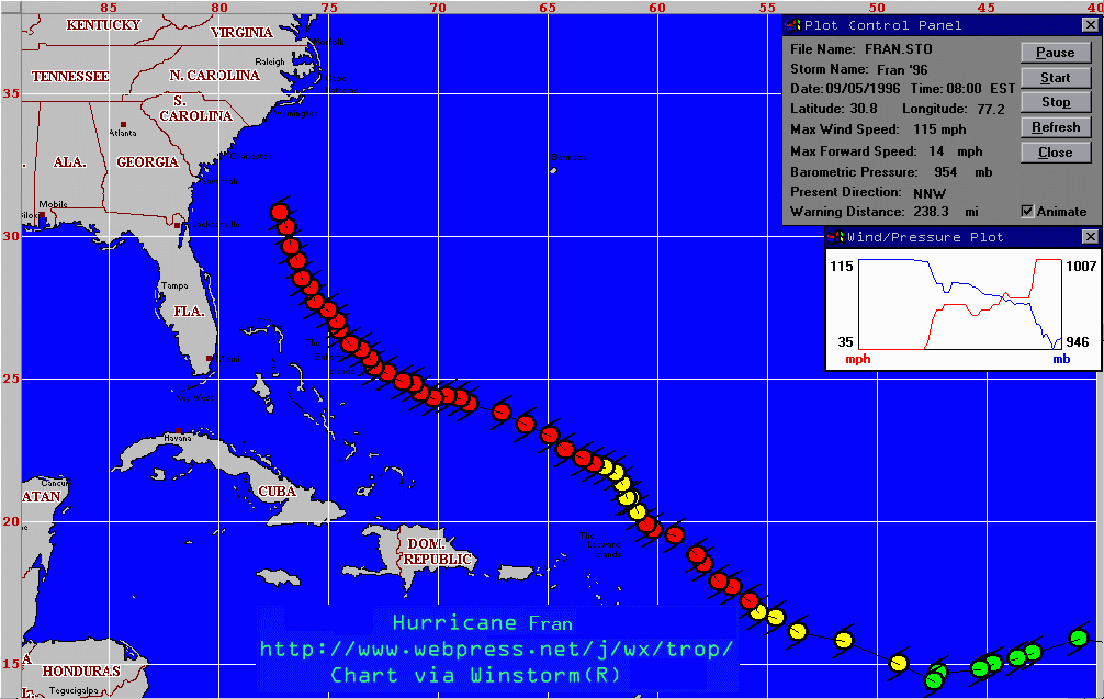
HURRICANE FRAN
I am stuck here at work in South Raleigh. Things are very bad. We lost
power to most of the city at midnight. Outside now there are
semi-constant generator flashes as the lines come down and explode.
Water has leaked into all areas of our building here and threatens our
makeshift power-set-up. There are many trees down. I attempted to go
back to my apartment at 1am, only to find that All major roads in
Raleigh are closed at this time. I tried to go home by the main
road, but a tree fell in front of my car and the police were blocking the
road. I asked how to get back to Millbrook at which point they explained
that all roads were closed and that was not possible. So here I am, I
can't even get home to check on my house or belongings. The wind and
rain here is equal to or greater than Hugo's inland damage. Although all
we have here is a 'vt' terminal, I caught a glimpse of a recent radar
that shows that the Triangle area will go through some VERY heavy rains
and winds for about another hour, then it should calm down.
Just returned from a trip down south to survey the weather. It was not apparent to me at first how much stronger this storm was than Hurricane Bertha. In the end, Fran took Bertha's path and came ashore in Wilmington. It continues to the north as of last statement. The current situation is thus:
Southport, NC: 100mph winds at 5pm.
Heavy Rains, high winds, and thunderstorms have overspread eastern NC.
Latest progs for landfall of the eye of Fran are near Wilmington, NC.
Schools and businesses in the coastal plain are closed. High winds and
heavy rains will continue throughout the night in the eastern half of NC.
It's getting bad. I'm even a little wary myself; people were taping up
store windows in downtown Raleigh today at noon, and we're hundereds of
miles inland. Landfall still looks like about at the border.
Hurricane Fran continues towards the NC/SC border. I drew up a quick
Map of the Expected Effects of the Hurricane on
the Carolina area for tonight and tomorrow. Mandantory evacuations are
now in effect for all beaches in SE NC and SC. A rain band containg very
heavy rains is on its way to the coastal plain as we speak.
HURRICANE WARNINGS EXTENDED to VA/NC border. EVACUATION SPECIFICS in graphical and text format are
available.
Storm still same strength,
same heading: towards South Carolina. See Ground
Zero Surface Obs as the storm approaches.
HURRICANE WARNING ISSUED for GA, SC, NC coasts. Madantory evacuation for
islands and South Carolina. RAIN: 5-10" additional. WIND: 115 + gusts.
STORM SURGE: 12-16 feet above nornal. This is what is expected for
the Carolina coast around midnight tomorrow. After that, expect flooding
into the carolinas and virginias. This storm is close to the strength of
Hurricane Hugo which hit Charleston, SC, in 1989. It has shown a slight
turn towards the NNW today, confirming forecaster's estimations that the
upper level low pressure system over tennessee steers the hurricane.
Intensification is quite possible during the next 24 hours as the
hurricane approaches the Gulf Stream tonight. Once again, the most
likely position for this hurricane early Friday mornings according to
the forecasters is between Charleston and Myrtle Beach, SC.
Eastern NC is under a large area of heavy rain, and, despite what
Some local
meteorologists are rumoured to be saying, it is the first band
of the hurricane moving through. It is, however, being aided by
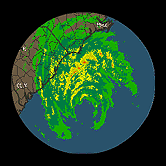
moisture that was already over the area. This large rain band (see
Wilmington Radar at 1pm) will
be moving into the Raleigh/Durham area later this afternoon. Initial
rainfall estimates are between 8 and 15 inches of rain in some portions
of the coastal plain of NC!
Eastern NC has already seen rain and thunderstorms this morning from
a feeder band spreading north-westward over the state. As I imagined,
the predicted track has shifted north and landfall is now predicted
to be at Myrtle Beach, SC. Course, that's where Bertha was supposed to
hit also...
Fran's pressure has continued to fall overnight, and the winds will
likely be increased at next recon report. A slight turn to the NW is
predicted as the hurricane is 'caught between the cogs' of a high pressure
system in the NE US and the upper level low/trough in the Midwest. Current
projections are looking at landfall in South Carolina late Thursday/early
Friday. After that, some models predict that it will travel all the way
to the Great Lakes. In any case, it is looking suspiciously like Hugo in
1989. Unlike Hugo, however, this storm is more likely to move slowly
through the Carolinas, bringing more rain but less wind.
HURRICANE WATCH ISSUED FOR SOUTHEASTERN US. Fran has increased rapidly
today from a minimal Category 1 storm this morning to a full fledged
Category 3 storm this evening. Winds are now sustained at 115mph.
Fran is on her way for the Southeastern US. First it will brush the
Bahamas. Current track has it coming on the US Shore late Thursday to
early Friday. Even after it moves inland, the eastern US should be prepared
for soaking rains that will come on top of already saturated ground.
Hurricane Fran has increased in strength slightly. Although yesterday
progs were bringing it into florida, the latest forecasts are going for
more of a South Carolina hit. When? Late this week. Meantime: the
islands are preparing to be hit. Hurricane and TS Warnings are out
for the islands today.
Fran is now strengthening and is now at 80-mph and continues to drift
towards the NW.
Fran shows signs of possible strengthening as it seems to be getting
more organized. It is entering a favorable area for
development.
Fran continues to fluctuate in intensity and move towards the NW.
Fran is downgraded to a Tropical Storm and will likely be in the shadow
of her big brother Ed until he is gone.
Hurricane Fran continues as a minimal hurricane and is approximating the
path of Ed.
Fran threatens the Carribean as a minimal hurricane.
The Hurricane Center is now issuing 3-hourly updates on Hurricane
Fran, which is approaching the islands. If this storm is far enough
south it could slip under the troughs and pose a threat to the Eastern US
next week.
Tropical Storm Fran is soon to be a hurricane. She will be much closer
to the islands than Ed was, but she is starting to show a slight
turn to the NW.
Tropical Storm Fran is on Ed's heels and is quickly strengthening. May
well be a hurricane by tomorrow.