 Eastern
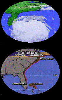
Hurricane watches have now turned into warnings for the carolinas
and Georgia. The storm has started turning slightly to the North
as a pronounced upper level trough swings in from the north.
Still, the forecast is uncertain. It appears that, perhaps,
instead of being "kicked out" by the trough, it may get stuck under
the trough as it works like a gear spinning out in the Atlantic.
If this is so, further strengthening could take place. Already,
pressures have ast have started to fall once again. Do check out
CNN's
Forecast Maps.
Hurricane Watches are now up for the Southeastern U.S., as the storm has
not yet turned to the North as was expected.
Hurricane Warnings continue in effect for the islands only,
although a watch is expected to be issued for the Southeastern US coast
by 11 tonight. The first trough swinging around the upper low failed to
effect the storm, and the fear is that the second will also miss Bertha.
It is still too early to say. A continuation of the current track would
bring it to around Savannah, GA by Thursday. Considering that it
is expected to change course to the North by tomorrow, a better
bet would be South Carolina, or the Outer Banks of North Carolina which
jut out considerably more than the surrounding geography and tend to get
clipped by passing hurricanes.

Winds constant, pressure rising. All changes
are negligible at this time. Has not turned to the North yet,
forecasters expect it to tomorrow. Meantime those with interests in GA
and the Carolinas should keep a close eye on the situation.
Cloudiness from the Hurricane could reach the Carolina coast as early as
late tomorrow afternoon if it continues on the current track.
Pressure has bottomed out and is now on the upswing.
More intensification occured overnight to the hurricane than was
expected. It now packs winds of 115 MPH and continues onthe same
heading.
Hurricane Bertha has left the building. Or, left Puerto Rico in any
case. Likely to become a category II. hurricane by tomorrow
morning. Miami should be taking precautions and keeping a close eye
on the storm.

90 MPH winds, likely 100+ in the higher terrain of Puerto Rico. Storm
moving to the WNW, likely to turn
NW. Residents in the Southeastern US are being urged to begin to take
precations.

The Hurricane (now with winds of 85 mph) will brush Puerto Rico within the
next few hours and then will head towards the SE US.
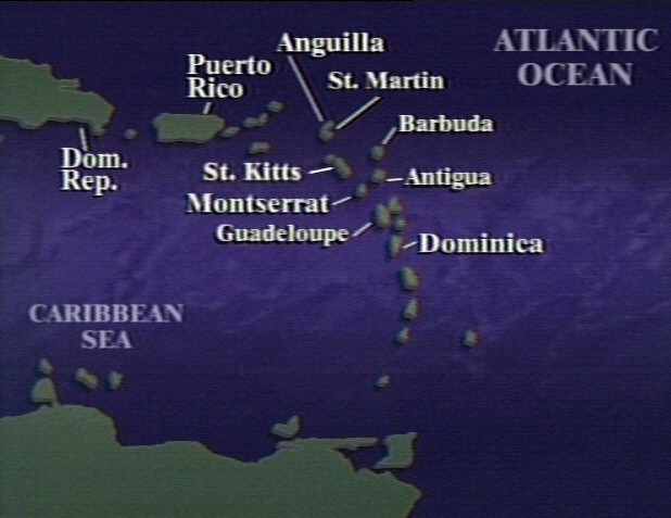
Hurricane Bertha has pummelled Antigua and is now headed towards Puerto
Rico.
Bertha declared a Hurricane by NHC at an hourly update. Nearing Antigua
and Barbuda this hour. After that? Looks like an unusually strong storm
system that is making its way to the eastern US may push Bertha to the
north before she hits the US. Maybe.
Bertha continues with winds at 70mph. She does appear to be increasing in
heavy thunderstorm activity.
Tropical Storm Bertha may be about to become Hurricane Bertha, with winds of 70mph. Hurricane Warnings are in effect for the islands. Residents should take cover immediately.
Bertha is slowly gathering strength and is headed towards the Lesser
Antilles. Winds are only 45mph but the storm seems to be getting better
organized.
The second tropical storm of the year, Bertha, is a minimal tropical
storm in the Atlantic. At this time it threatens no land.