| Headline: 7pm, December 27, 1997.
Place: National Meteorological Center
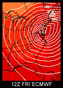
Weather Forecasters blink at the black and
white DIFAX maps slowly churning out of the large printer. The latest
model runs. But something is amiss. NMC - WASHINGTON -
|
| HEADLINE: 11am December 28, 1997.
Place: State College, Pennsylvania.
It's a "nice" day in Central Pennsylvania.
The temperatures are in the lower 30's. The news of the impending
storm hasn't yet hit the public. The lines at the grocery store are
small. |
A major East Coast storm may be on the way. CASI Members were put on alert late Saturday, 12/27/97, to report thoughts, observations, and forecasts to HQ for relay to the other members and this web site.
This web site will be updated throughout the storm.
Some are comparing the theory of this storm to the Superstorm of 1993.
NWS's statement from NWS-UNV at 9:30am today (thanks Bud):
"ANALOGOUS STORMS TO THE ONE COMING UP ARE THE MAR 93 SUPER BOMB ...WHICH FOR THE BENEFIT OF THOSE WHO JUST MOVED HERE OR WHO WERE NOT ALIVE THEN...DROPPED MORE THAN 2 FEET OVER MUCH OF THE AREA...AND THE 18-20 FEB 72 STORM WHICH ALSO PUT DOWN WIDESPREAD SNOWS APPROACHING 2 FEET."
The latest (8:00pm 12/29): The storm has turned out to not be as large of a snowfall maker as previously thought, in fact, we've had no snow at all here in Central PA. Low pressures and high winds have been observed on the mid-atlantic coast.
(11:00pm 12/28): As is usually the case the night before the storm, nobody knows what's gonna happen. I've had as many people say that the storm is going east off the coast as have told me it's going to go well inland. The track of the storm will make or break the snowfall amounts vs. rainfall amounts. Weather Channel is a little worried that the cold air isn't coming as far south as they thought but at the same time SC temperatures are below freezing.
(4:30pm 12/28): Reports are that forecasters are rapidly "jumping off the snow bandwagon" for this storm and predicting rain for the big cities in the mid-atlantic and Northeast. The NWS here in State College PA has put PA under a Winter Storm Watch. See Central PA Forecast below for more info on that.
Here are some links to keep an eye on developments:
How To Join / More About CASI
Send corrections / questions /
suggested links to j@weatherwatchers.org