TARRANT COUNTY TORNADOES |
New information added 8:00 pm, March 31. |
These images were captured on our FOX 4 Warn Doppler Radar on March 28, 2000. At least two tornadoes touched down in Tarrant County. The time of each image is noted in the upper-left corner. All images approximately 25k bytes. |
 |
| 6:13 pm The hook shape created by the counter-clockwise rotating thunderstorm is clearly visible as the storm enters the northwest corner of the county. The circular area near downtown Fort Worth is "false echo", which means the radar is seeing the office buildings that would eventually be hit by the tornado. |
 |
| 6:18 PM Baseball and softball size hail was falling between Lake Worth and Saginaw. Meantime, just a couple of miles west of downtown Fort Worth, the tornado touches down and stays on the ground for about 2 miles. The damage path was about 1/4 mile wide. |
|
| 6:23 pm At about this time, the tornado is moving over the Cash America building just west of downtown. The damage in this area was ranked F-2 on the Fujita Scale, meaning the tornadic winds were blowing 113-157 mph. |
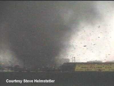 |
| This was the view captured by amateur videographer Steve Helmstetler from near downtown Fort Worth, looking southwest as the tornado moved closer. |
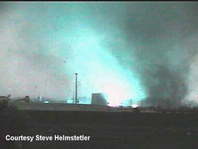 |
| Steve's camera catches the tornado passing over an electrical transformer, which causes the bright blue explosion on the ground. |
 |
| 6:28 pm It appears that a rainband is being pulled into the rotating thunderstorm as it nears downtown. This shuts off the inflow and causes this tornado to weaken. |
 |
| 6:33 pm A new area of circulation is showing up near Edgecliff Village in southern Tarrant County. This would eventually become the Arlington tornado. |
 |
| 6:43 pm The FOX 4 Warn Doppler Radar shifts to Arlington as a new tornadic storm begins to form. What's left of the Fort Worth tornado is visible in the upper left corner of this image. |
 |
| 6:48 pm At this point, the new storm will still showing signs of rotation, but no tornado was reported on the ground. |
 |
| 6:53 pm The "hook echo" is becoming more obvious, visible here just northeast of Kennedale. |
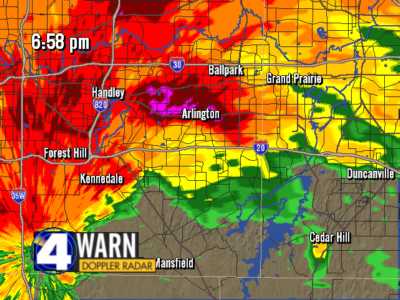 |
| 6:58 pm The circulation is beginning to intensify. |
 |
| 7:03 pm Another tornado touches down near Cooper Street, just south of Interstate 20. This tornado was 1/4 mile wide and would be on the ground for approximately 6 1/2 miles. |
 |
| 7:07 pm F-3 damage was reported near Bardin Road and Matlock. The winds in this tornado were blowing about 158-206 mph. |
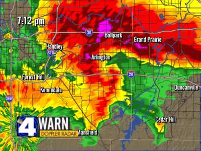 |
| 7:12 pm The tornado weakens from F-2 strength to F-0 as it crosses Interstate 20 and Highway 360, before moving into southwest Grand Prairie. |
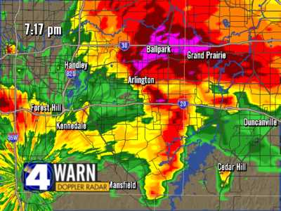 |
| 7:17 pm The tornado strengthens regaining F-2 strength right before it tears apart another neighborhood along Arkansas Lane in Grand Prairie. The tornado lifted shortly after crossing Spur 303. |
| All comments written by Tim Heller, Chief Meteorologist. All radar images copyright 2000 FOX Television Stations. |
