Current Weather At CASI HQ: Click Here For More Info |

| MAIN | STORM REPORTS | US SEVERE | MEMBERS | JOIN CASI | HELP/CONTACT | CAM |
|
Central |
|
|||||||
| Atlantic | |||||||||
| Storm | |||||||||
| I
n v e s t i g a t o r s |
|||||||||
|
|||||||||
|
Severe
Thunderstorms / Tornados |
|
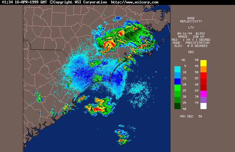
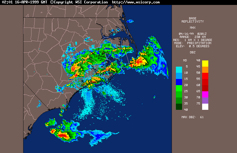
LAST UPDATED 4/22/99 jf On the evening of April 15, 1999, a number of severe thunderstorms travelled through eastern NC, spawning tornados and causing 1 death in a mobile home park in Duplin County. A 165mph gust was recorded by an Amateur Radio Operator, purportedly by a Davis Weather Monitor II personal weather station in Trenton, Jones County. The 165mph gust Local Storm Report (LSR) from the National Weather Service in Raleigh NC is presented below.
WWUS30 KMHX 160238
LSRMHX
PRELIMINARY LOCAL STORM REPORT
NATIONAL WEATHER SERVICE NEWPORT/MOREHEAD CITY NC
1035 PM EDT THU APR 15 1999

TIME(EDT)  .....CITY LOCATION..... STATE  ...EVENT/REMARKS...
           ....COUNTY LOCATION....

1020 PM    TRENTON                   NC   165 MPH TSTM GUST
04/15/99   JONES                          WIND EQUIPMENT SHOWED
                                          GUSTS TO 165 MPH, BARNS,
                                          TREES DESTROYED, ALL
                                          HUNTING DOGS KILLS, N OF
                                          TRENTON
Also, the following observations of
interest were recorded in Eastern NC last night. I am told that this
means that the Base was preparing for a tornado. Jacksonville,
New River, Marine Corps Air Station, NC, - At 3Z 4/15 reported the
following:
KNCA 160256Z 26019G28KT 4SM +SHRA FEW008 SCT020 OVC030 22/21
A2954 RMK TS OHD DSIPTD SLP003 TORNADO COND I SET 60051 8/8// T02220206

KNCA 160307Z 28008KT 7SM  SCT020 BKN030 OVC070 22/21 A2954
     RMK SLP003 TORNADO COND I SET=
Also, the following observations of
interest were recorded in Eastern NC last night. I am told that this
means that the Base was preparing for a tornado. Hatteras, NC
- At 2Z 4/15 reported a Squall, Pressure Falling Rapidly, and a
Max Wind Gust of 75mph (66 knots):
KHSE 160151Z AUTO 30018G66KT 1/4SM +RA SQ FG FEW004 BKN010 OVC027
     21/19 RMK AO2 PK WND 30066/0147 WSHFT 0117 PRESFR SLPNO P0118
     T02060194 TSNO $=
A complete 24-hour list of official METAR observations from Eastern NC is available here for your perusal. It includes the following stations: 37W - Harnett
Co, Erwin Other Resources For These Storms:
|
© 1999 Central Atlantic Storm Investigators |