Live Storm Investigation / Chase Report - Jesse Ferrell, CASI President
The date was Jun 2, 1998, and I would realize later that day that it was the one-year anniversary of my best video of a storm - the Jun 2, 1997 Severe Thunderstorm in Raleigh. Many people would see tornadoes that night. Unfortunately, I would not be one of them. A combination of lack of knowledge of the area, shifty storms, and spending too much time debating and less chasing would leave me with no tornado footage by the end of the night. But that wasn't the case for CASI entirely - several of our Members witnessed wall and funnel clouds that night as what some would call the "Severe Weather Event of a Lifetime" passed through Pennsylvania.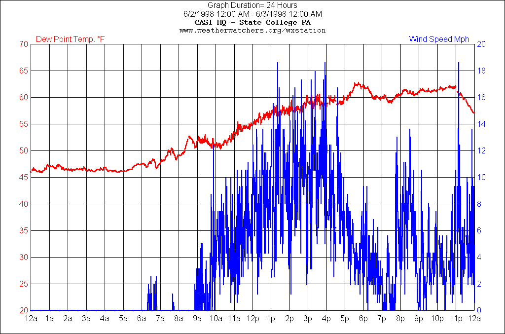
It was a Tuesday so I was at work until 4pm, but keeping a close eye on the radar there. The morning had started out with very low dewpoints, a result of a front that had pulled through after Sunday's event. NWS-CTP and I, along with people at work, were both worried about the amount of moisture in the air - a dewpoint of 45 had started out the morning and I wasn't sure if I could give faith for the atmosphere to bring it in - but a SW breeze started up late morning and pumped juicy air into the area - upping the dewpoint by 20 degrees to about 65 late day. See Figure 1 for a graph of Dewpoint and Wind Speed from the CASI 1 Weather Station.
The night before I sent a CASILIST posting to the CASI Members. I try to do this everytime a Moderate Risk is issued, to alert the Members (though most of them already know ;)) about the Severe Weather Threat. We have Emergency Mgmt. personnel who need to be ready to go into action if a storm tears through their area and spotters who need to be keeping an eye out. Members planning to catch the storms on film need to prepare and have ample supplies, especially after exhausting them with Sunday's event. Moderate risks are, of course, rare in PA and this was the second one in three days. Could it bring a severe weather event worth of the Risk? SPC had hit it right on the nose Sunday with Southern NY being the center of the risk. On the evening of 6/1 they were guessing at a small area including Maryland, but by the morning of 6/2 most of PA was included.
Around 2pm storms started developing in Ohio, some becoming severe. They started to appear on the State College (Central PA - Home of CASI) UNV NEXRAD before 3pm. I squirmed like a snake at having to be at work for another two hours, but it turned out the storms were slow movers, or I should say slower than Sunday, when they were clocked at up to 90 knots by NEXRAD (and that may have been an exaggeration but they were averaging 50-70). Today we seemed to be looking at 25-35.
As I left work at 4pm I could see a boiling Cb to my south. The CASICAM saw it too. The visibility was excellent for these storms and the growth of the clouds was easy to see, with a pileus cap already topping one of the Cb's I saw before I arrived at HeadQuarters.
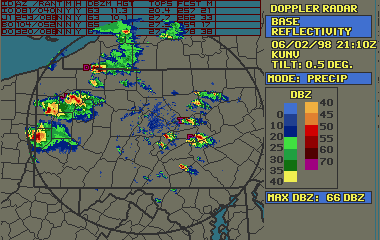
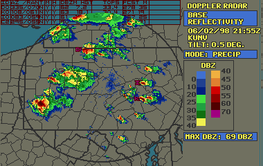
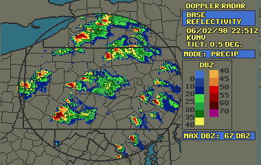
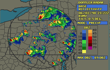
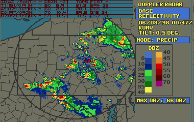
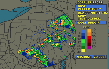
The most interesting storm of the day had to be the cell that came out of OH into West Virginia. It was an intense and long-lived Supercell, very impressive on radar. It was responsible for many Severe Thunderstorm and Tornado Warnings as it traced a path from West Virginia to North Carolina.
Supercells were already coming out for the OH/PA border when I arrived home just after 4pm. Bob, my neighbor who had accompanied me on the rather lame Friday chase was ready for more action. We sat in front of the computer and the weather channel for hours tracking the storms, trying to decide what to do. As usual, I remind folks that it's tough to justify leaving HQ because of the good view. But a good view hadn't done me any good the last several times as the storms routed around me.
I was surprised to hear the alert tone go off at 4:45pm for a Tornado Warning for the storms to my east! They didn't look *that* good on radar, and although they had developed after I got home they were (apparently) intensifying rapidly.
Another Tornado Warning came out for our east. That was where we should have been! But no going there now, with stuff moving away from us.
17:10pm and there were 3 supercells heading our way. Which would make it over the mountains and which could we get to in time?
Not to worry as the ones nearest to us seemed to dissipate. The next hour Warnings are going out like crazy to our east, one after the other. Then at 6pm one storm hung back behind the pack in Clarion county and started to intensify! Just before 6pm the Warning is issued! This is our storm!
Should we stay or go? It looks like it will track through the southwest part of our county. We hesitated, trying to decide where to go.
At 7:00pm we were looking at the radar (supercells are everywhere) and decided it was time to head to the SW - it looked like the strong cell would hit there. What I didn't take notice of was a small cell forming to the NE of that storm, which would have bearing on our chase in a matter of minutes. As we left another Tornado Warning went out. At first it looked like a job for our Friday chase area, 45 south of town - then as the storm approached it took a more southward turn and it became evident that if we were going to catch it while it was still intense we'd have to take 220 rather than 45, SW towards Altoona. A final check of the Storm Track placed it in Tyrone near 8pm. Unfortunately, the track I was looking at at 7pm was 15 minutes old, I had forgot to reload the picture. We left just after 7 but were 15 minutes behind. Heading out 322 to catch 220 a Tornado Warning is broadcast - tornado spotted 29 miles west of Tyrone, will be in Altoona at 7:35. Altoona?? Could it have gone that far south? Bob is much more familiar with the area so I asked him the ultimate question - can we make it? The answer was no and we turned around and debated where to go next. See our short stint on the chase map (red is the original trip and blue is the return) We considered several options. Unfortunately there is no road straight south of State College which is what we would need to catch it in time and not let it get too far South. We were coming back to the 26 exit again and needed to make a decision. Bob suggested I pull into the shoulder at the exit so we could look at a map. Time 7:22pm.
But the decision was made for us as the EMS tone alerted us, just as I stopped, of a Tornado Warning for our county - tornado 25 miles west of Bellefonte, site of Friday's F0, progged to be in Milesburg at 8pm. That was NE of us, but 26 was a shoe-in to 150 which would put us in Milesburg before 8 o'clock. Looking at the radar later, it wasn't much of a cell.
And off we went. Nothing much to show for the storm until we got close to Milesburg (passing right by the F0 Bellefonte tornado site from days before on the way) when things started darkening up. But where was the storm? We hit 220 north of Milesburg. There seemed to be dark clouds to our right and I stopped to video some interesting scud and movement. Surely this wasn't it? What we didn't know was that the storm had dissipated considerably and its remnants were all around us. What we also didn't know was that the original storm we had set out to chase was now plowing through 45 where we would have been had we not been fooled by a Tornado Warning from a *different* southern storm. (See radar).
Now it becomes a little hairy because the UNV radar goes down at 8:02pm and doesn't come back up until 8:27. This would have been bad news if we had radar in the car, but we didn't know one way or another so we didn't care. At 8:20 we were heading back through Bellefonte to hang it up when we suddenly were caught in a massive lightning display. Bob captures a couple good streaks on video while we're sitting in the same parking lot that I took pictures from Saturday on the Friday F0 investigation. Things are looking severe. I wasn't sure what was going on but I knew it was good. We pulled over to take stock of things on the way to 26 from Bellefonte. While we're sitting there the EMS tone goes off and its a Tornado Warning for Centre county, where we are sitting! (Unlike us, you can check the radar from that time ;)) A tornado is 24 miles west of State College (CASI HQ!) moving East at 35mph, progged to be in State College, that's at or near CASI HQ, by 9:30pm. We believe the projected movement and this is where we go wrong. We think we have enough time to hit it on Whitehall Road or thereabouts in Pine Grove Mills at 9:30. We take 26 through town. I considered going 45 south of town and coming back up, but we figure the thing is headed right for downtown State College, why swing south?
Lightning is still considerable about 9:20 as we come out of the city on 26. While we were passing through downtown it started to become painfully obvious that this storm was not here and we were going to miss it. Within a matter of minutes the moon popped out straight overhead! What had happened to the 9:30 hit? The radar confirmed the storm had gone south. That was it for the night - it was completely clear behind the storm and the moon lit the road for the way back to HQ.
ANALYSIS: What We Did Wrong on this Chase
Sometimes the most important part of a chase is finding out what went wrong so you can prevent it next time. This was a good chase in that it got quite exciting, but a bad chase in that we seemed the odd men out in tornado reports that night. This event would later be called the "severe weather event of a lifetime" by some in PA and I do have to say that I was disappointed to have not been able to investigate storm rotation or at least get some video of it. I certainly learned a lot from this chase. So here's why we didn't see a funnel while half of PA's population were reporting them:
General Problems:
My unfamiliarity with the county and city names and roads. Bob
was a huge help on this however and it became a very small problem.
Chase Summary Illustrations:
Shortly after 5pm several things became apparent, here I illustrate
with Figure 1 - UNV with Movement Vectors from 5:21pm.
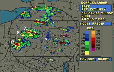
HeadQuarters is in the middle of the picture at the asterisk (*).
This was one of the last radar shots where you could think that the storm
at (A) was still a viable storm. It was decreasing in intensity and
there was enough anvil blowoff in front of it to cut down on stability.
It was still moving generally to the ESE and this was our original first
thought on storms. (B) had just started to increase in intensity
at this shot and now became our best bet. We all knew (C) was the
place to be but there was too much road in front of us to get there in
time.
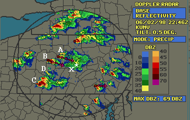
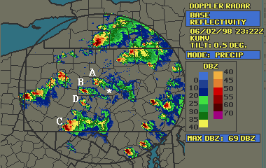
Figure 2 was what we based our chase strategy on. It looked like (A) continued to dissipate, (B) was headed straight for 45 south of town, where we were on Friday, and (C) continued unabated. What we didn't pay attention to was (D) which was just forming. It would fool us in a few minutes. The Tornado Warning at 7pm was for storm (B), as we left HQ, heading towards the SE to catch it.
As we were driving we heard the second Tornado Warning, which we assumed was our storm, but we both didn't know the counties very well, or weren't listening, and thought that (B) was the second Tornado Warning. Looking at the radar map in hindsight it was reasonable to think that the storm couldn't have progressed that far in that short amount of time, but for some reason we thought it had, and turned around.
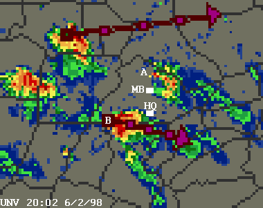
In Figure 3 we see that (D) has become a full-fledged cell of its own, (A) is holding its own, (C) is splitting in two, and (B) has dissipated a bit. It was at 7:23pm when the Tornado Warning for Centre County, (HQ's county) was issued. The reported Tornado was in (A) headed E according to NWS. The radar vector had it ESE. Either way both agreed it would be near Milesburg at 8pm. At this point we headed NE past HQ (*) towards Milesburg, at the (x). Little did we know that (B), our original storm, was still hot, but not producing Warnings. If we had the radar in the car, (B) still would have looked like a better bet. But we didn't so we went for (A).
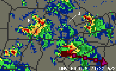
Time is 8:02pm. In Figure 4 we have zoomed into the area in question for more detail. (A) has dissipated and moved east, the greatest dbZ portion moving to the North of Milesburg, which was where we had parked ourselves. Our original storm (B) has grown in strength and is clipping HQ. New storms have formed to our NW in similar positions to where (A) and (B) were earlier, but without radar in the car we don't know this. Had we chased our original storm (B) we'd be in the thick of it about now. ;)
Time is 8:37pm, we're heading through Bellefonte and Bob has just caught
an awesome CG on tape. The rapid lightning is coming from a tiny
cell that just formed in the middle of the county (Figure 5), over our
location, which explains the sudden influx of lightning, but is only 40-45dbZ
(where (J) is pointing). Meantime the cells at (E) are squarely headed
for an interception of the southern part of the county, possibly including
HQ.
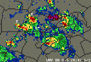
The next series of shots are from the next 3 10-minute intervals on
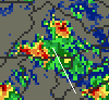
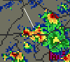
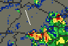
the UNV radar. At 8:58 a partial hit for State College still looked
like a possibility, but the bulk of the storm was going to the south.
At 9:08 this was confirmed and at 9:18 the bulk of the storm had reached
State College's longitude but was south of the county border. It
also appeared that the storm was faster than expected as this was 10 minutes
earlier than the warning had specified. In all illustrations the
location of downtown State College (and also location of our chase at that
point) was at the tip of the white line near the center of the picture.
 |
 |
 |
| 8:58pm | 9:08pm | 9:18pm |
1. Win a sweepstakes so we can get a laptop for radar
in the car. ;)
2. Know your counties.
3. Don't take NWS progs to be *exact locations*
even if all you have in the car is a weatherradio.
Prog the storm with your eyes or head in the direction that general movement
has been.